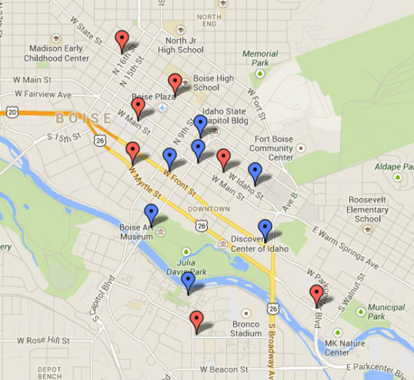
Proposed Service Area Map

Below is a map which shows the proposed locations for bicycle stations. The bike stations will be primarily located in downtown Boise and the surrounding area. The blue locations indicate possible station sites under Phase I. The red sites are proposed locations for Phase II. An explanation of the stations is located beneath the map.
We welcome your comments and suggestions. dfotsch@boisebikeshare.org
We welcome your comments and suggestions. dfotsch@boisebikeshare.org
Proposed Station Location Narrative
Blue Dots - Phase I
Old Borah Post Office
This location is close to downtown eateries, the Capitol, condos and offices. The location has broad sidewalks and is state-owned property. SW corner of 8th and Bannock.
City Hall Plaza
The City Hall Plaza is going to be renovated soon, it is a broad open space with high visibility. Since it is city owned property and the city supports bike share, this seems like a logical location. East side of Capitol Blvd between Main and Idaho.
Boise Centre on the Grove
This is a big open space where citizens gather in the summer for Alive After Five and the Saturday market. High visibility and publicly owned property make this a good choice for a bike station.
We are looking at an area that is currently grass on the north side of Front Street, the SE corner of the Boise Centre on the Grove. It is an indentation off the main 8th Street pedestrian corridor, directly abutting the Centre building.
St. Luke's Campus
St. Luke's represents an dense, 24-hour, seven-day-a-week employment center. The campus is just a little bit too far from the downtown core for people to walk for lunch. The campus is crowded, but there might be the possibility of using parking spaces in a surface lot on 2nd Street between Idaho and Bannock, or south of Main Street near an employee parking garage.
East end of Downtown
The original suggestion was for a station at the Ada County Courthouse, but the stakeholders thought that placing the station further east, near the U of I Water Center, Winco and Whole Foods would be a better location. High visibility, residential population in apartments, retail destinations, the U of I campus and state offices all make this a good location. There is a broad, open plaza that wraps around the Water Center to the South and Southwest. There is already existing bike parking.
Cultural District Area
This area offers high visibility and access to the Boise Public Library on one side of Capitol Blvd and the Art and History Museums on the other. It also offers great access to the Boise Greenbelt and the Boise State University campus. Not far to the north are several large hotel complexes and BoDo, a retail, office and dining and entertainment destination. It was thought by the stakeholders that putting the station on the Capitol Blvd would increase visibility.
The actual location would be in 2-3 current street parking spaces on the west side of the street in front of the Boise Art Museum. We suggest the spaces furthest to the north, close to the entrance to the park.
Albertson Library BSU Campus
The original proposal was to put bike share on the Quad at BSU, but the campus transportation plan doesn't allow bikes on the Quad. There is open space to the NW of the Albertson Library, which is currently bike parking. There is also a bike path nearby. This location is also near residence halls on the BSU campus. There is a bridge that crosses the river not far from this location that would facilitate traffic from Julia Davis park.
Red Dots – Phase II
YMCA Area - State & 11th
The YMCA has a terrible parking problem with its downtown facility. The stakeholders felt that a bike station nearby might help to releive some of that parking problem if members could jump on a bike from another location and ride to the Y. This is a highly visible location along a transit route, and within a block of Boise High School.
The actual location is yet to be determined. There is surface parking all around the intersections of 11th and State, and 10th and State. Installing bike share stations would involve losing some surface or street parking.
Idaho Power Plaza
The stakeholders felt a bike station on the Idaho Power Plaza might offer a number of advantages to providing bike share to the western part of downtown. It wouldn't intrude on the public sidewalk because its private property. It would be across the street from Idaho Mountain Touring, a bike shop, and it would serve the employers in that part of downtown, especially Idaho Power itself.
There are a couple of alternative to this site: The Boise Plaza one block north and east, has many of the same attributes, and in some ways is superior to Idaho Power because of it’s broad sidewalks and surrounding surface parking lots. Finally there is an area near the Owyhee Plaza. This would have to be in street parking spaces because developer Clay Carley says he won't give up space in either of his parking lots.
URS Business Park
This would be the most easterly location for a bike share station. The group felt a station should be located on the east end of this property because of its access to Municipal Park, the Greenbelt and the employment area that is the URS Plaza. Also there will be new development at this intersection in the near future.
BSU Student Union Building
There is a broad plaza area on the SW corner of the Student Union Building that has existing bike parking with space available for a bike share station. This is a highly visible location near several important buildings on the BSU campus. The Lincoln Parking Garage across University Drive from the SUB, houses the Cycle Education Center. A block to the east is the Recreation Center. A bike station in this location could serve multiple audiences as they try to get around campus.
17th & State
This is a highly visible location on a transit line that would provide a linkage from downtown to the northend. In this area are a number of retail stores as well as restaurants and offices. The parking lot on the soutside of Albertsons closest to State is under-utilized and could be a potential location. On 17th Street there are pull-outs that could also host a bike share station.
State Office Complex
An actual location for this proposed station has not been identified. However, it is felt that there needs to be a link between the proposed location at St. Luke's and downtown. State offices employ a lot of people who could use bikes to get to downtown, or run to other state offices.
The downside would be that bikes at this station probably wouldn't see much use on weekends.
JUMP - Jack's Urban Meeting Place
Jack's Urban Meeting Place seems like a good location for a bike station, as long as it is put on the SW corner of the lot, near 11th St and the nearby Pioneer Pathway, that connects to the Greenbelt. JUMP is going to be an attraction in of itself, but this location is also within a block of several downtown hotels and offers ready access to the Greenbelt. This would be private property, but the design of JUMP should allow for some open plaza space that could accommodate a bike station.
Another Way to Look at the Service Area
The map below looks at the proposed bike station locations by measuring the distance between stations. One-quarter mile is generally considered walking distance, or about a five minute walk. The areas covered in red represent this distance. Bike sharing is intended for short trips, and short trips are anywhere from one-half mile to three miles. While each trip will vary by individual, a half-mile is generally considered the point at which it becomes more convenient, and faster, to use a bike than to walk. The areas in blue on the map represent a half-mile distance.
Ideally, There would be overlap in the red areas so that no station is more than a half-mile from another station.
By looking at our proposed service area this way we can make decisions based on the distance from one station to another. There are some pretty substantial gaps in parts of the service area presently. We can also use this technique to propose future expansion of the system.
